


Finland/Sweden
Märket Isle


At Åland, we chartered a boat that brought us close to Märket.

For the last meters we barked a rhib, that brought us to the Isle.
Saturday 7th july 2023
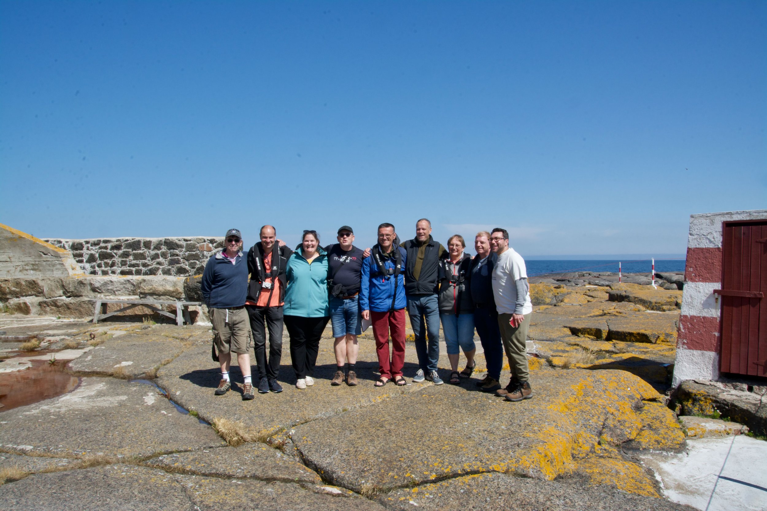
Nine members of the International border researchgroup (IBRG), with 5 nationalities prepare in the morning their trip to Märket Isle.
We met a day earlier at Stockholm airport, rented a van, drove 2 hrs to Grisslehamn and sailed with the ferry to Åland, passing the border at sea.


Mariehamn

At Åland, we stayed at Mariehamn, called after grand Duchess Maria Aleksandrovna of Russia. The statue is a gift of Russia because of the 150th anniversary of Mariehamn.
Mariehamn at Åland accommodates a Russian consulate. Opposite of the building there's a monument for Ukraïne. Every day at 5 pm people demonstrate here.


The complete tour was managed by Steen and Jonna. Many thanks for all your work and great compliments for the excellent execution.
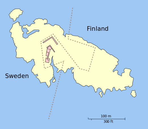
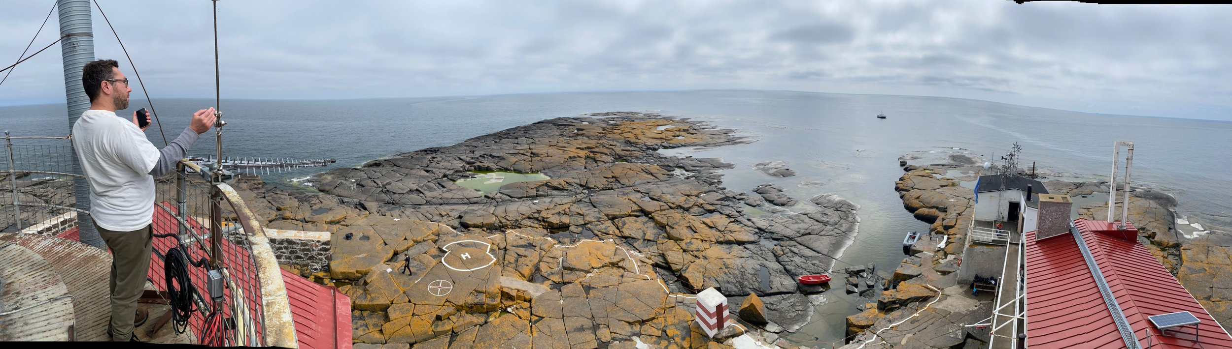
Märket Island
Märket is a small uninhabitant isle in the sea of Åland. It is situated exactly on the border in this sea and between the mainland of Sweden and Åland (Finland).
Märket has a border and half is Finnish, half is Swedish. The Swedish part is devided as well. The biggest part belongs to the region Uppsalalän, a much smaller part belongs to Stockholmslän. So we could say there's an unofficially tripoint on Märket as well.
In the peace of Fredrikshamn (1809) the original land border that ran through the middle of the island was established. A border correction took place in 1985 because Finland, which was part of Russia in 1885, built a lighthouse on the island in that year. It later turned out that the lighthouse was on the Swedish part. Finland became an independent country in 1917.
The border was later adjusted so that the lighthouse came on the Finnish part of the island. The size of everyone's territory was not allowed to change and everyone's share of the coastline was not wanted to change as this would affect the fishing rights (quota) of the countries, which is why the border now has a strange 'Z' shape.


Expedition
On July 7, 2023, an expedition to this isle was organized by the International Border research group. I was able to get along as member of the group.
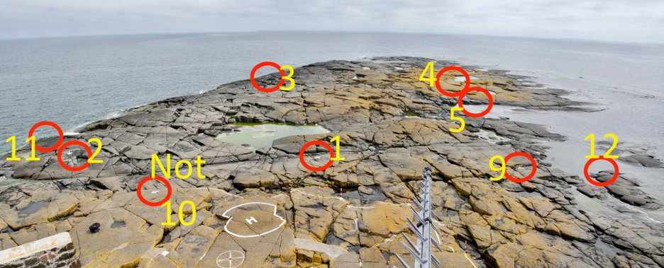
Because of the agreement of how to devide the isle, to everyone's satisfaction, on the isle the border is marked with 11 bordermarkers.
There is no (official) nr. 10, but in the middle of the isle, exact on the borderline there's a marker which I unofficially named nr. 10.

We are:
Barry Arnold (Uk), Jannis Deeleman (Nl),
Eva Rosová (Cz),Piet van der Giessen (Nl), Steen Schelde (Dk), Lars Hole (Dk), Jonna Nyborg (Dk), Jesper Nielsen (Dk) and Mike Kaufman (Usa).
The border between Finland and Sweden was determined by the Hamina peace treaty to run between Åland and the Swedish coastal archipelago. In the topographical description in 1811 based on the 1810 border arrangement agreement, it is stated that the demarcation line divides Märket islet in two. The same was repeated in 1888 in the topographic description.
In the 1921 non-fortification and neutralization agreement for the islands of Åland and in the 1972 continental shelf agreement, it is stated that the boundaries defined in them run through the center of the Märket isle.
In 1885, a lighthouse was build on the islet (arch. Georg Schreck). Since 1976-77, it has been an unmanned automatic beacon.
However, the border of the kingdom was not practically marked on the terrain. The fact that the lighthouse built and owned by the Finnish state was actually located on the part of the islet on the Swedish side brought its own strangeness to the situation. In 1981, the national border was carefully marked on the terrain and determined according to the attached map, when it was proposed that the area surrounding the lighthouse belongs to Finland and an area of a similar size belongs to Sweden by definition. The parliaments of both countries ratified the border agreement in 1985. At the border crossing, it was agreed that the traditional rights of the citizens and authorities of both countries to disembark will be preserved. Märket's credit with QSL codes (OJ) still is used in radio amateur connections.
You find the originally Finnish text here.
Instructions about the bordermarkers you will find here.
Märket
The border

The lighthouse
She's responsible for how the borderline now split the isle.


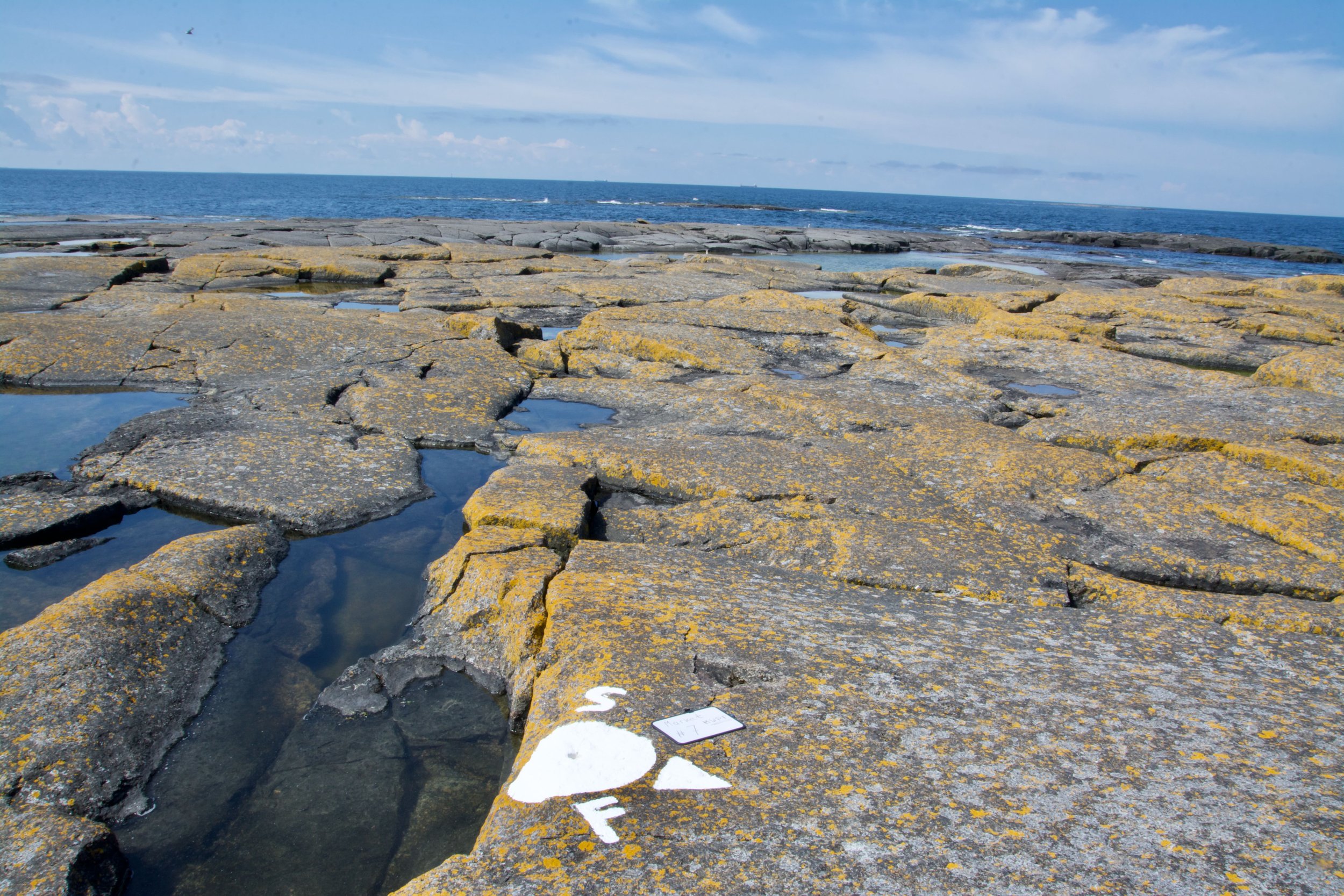
M W P F #7
We're entering now bordermarker no. 7. Actually it's a special marker.
Depending in what measurement you look or count, this marker is Mike Wisky Papa Foxtrot (MWPF),
meaning the
Most Western Point of Finland.
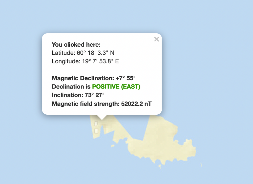
The measurements are the magnetic and the geographical. A geographic point will always be the same, so geographically BM no.7 will always be the most western point of Finland.
Magnetically, it's quite different. Mother Earth seems to be a giant magnet, but magnets does 'walk' around.
So a geographical point ain't always the same as a magnetical point. Besides this, it's also depending on where on earth you are.
The magnetic perception from my homeplace in the Netherlands, Märket will be 'about' at the same place as geographically. But on Märket, the magnetic declination will be +7º 55'.
I have to thank Lars for his masterclass about geographically and magnetically measurement.
Extra information I found (sorry it's in Dutch) here.
Bordermarker no. 7
MWPF
Special points like this I do like. I visited earlier:
- Most southern point of the Netherlands (BM 12)
- Most Northern point of Belgium (BM 219a)
- Most Westernpoint of the Netherlands (Bm360)
- Most Easternpoint of Bayern
- Most Western point of Finland (Märket BM no. 7)


Extra's and credits
In this section I will place some extra pictures which were send to me.
Expedition credits
Steen Schelde
Jonna Nyborg
Barry Arnold
Lars Hole
Mike Kaufman
Jesper Nielsen
Eva Rosová
Jannis Deeleman
Credits for hosting on Märket
Juuso (OJ0JW)
Anna
Jenna
Liisa
Päivi
Taina
Credits on photo's and extra information
Harry ten Veen (PA8KM)
Juuso (OJ0JW)
Pauli Kruhse
Links


The lighthouse was build on isle's highest point.
Above the remains of the former long mast.

Radioman Juuso (volunteer) send me this picture. He spotted this on the most Eastern part of the isle.
The engraved number 72121, can be 1 december 1972.
But what does it mean?

Kee Erikkson was the last lighthouse keeper and his shift ended to the automation on 1979. He worked rest of his career as a pilot near Port. Kee died last december 2022.

Inscription in the breakwater in front of the lighthouse. It says: Asessor, F. Granholm, Ar. 1887.
This is Gustav Florentin Granholm (1836 - 1922) who was a Finnish architect. However I couldn't find directly his involvement on Märket.
His name is mentioned as "byggnadskonduktörer" responsible for the construction of lighthouses all around the Finnish coastline. Byggnadskonduktör can be a supervisor, overseer (assessor?) at the construction site, or assistant architect, by Ms. Vivi Hörkkö.
See here her study.
In some books he's mentioned that he supervised the enlargement for that and the project was finished on 1887. So it's kind of check mark. He inspected that project four times, until he approved it.


The copper bold just in front of the right foot of our guide (white arrow).
Left from the stealbold bar there's a cupper bold, mounted in the rocks.
There's an inscription as well, looks me as SF 72


The most Easternside of Märket, the place Juuso (OL0JW) spotted the bold and inscription.

The stealbold bar is part of the masts, which has been replaced from the place from the picture above to the place near Bm 8.

And yes, the small red and white shed, for sure used to be the isle's toilet. Because the disposal went direct to open water, it ain't allowed to use it anymore.
After a typhoon in 1897 the longmast was rebuilded after damaging. Picture is from 1903.
(Picture from the book "Märket - majakkasaari kahden maan rajalla" by Jan Andersson)
© Op alle foto's rust het auteursrecht.
Vraag s.v.p. vooraf om toestemming als je foto's gebruiken wilt.©
